ECO-CICLE RUTA 29: R3 - Los Aguardianteros. Parque Natural Sierra Norte de Sevilla. Alanís. Sevilla. Andalucía
near Alanís, Andalucía (España)
Viewed 84 times, downloaded 8 times
Trail photos


Itinerary description
Esta ruta pertenece a la oferta BTT de Alanís:
Los Aguardianteros
Salimos desde la Alameda del Parral, atravesando el casco urbano por la calle Hierro, pasando por finca “Los Tejares” entre olivos y encinas y tomando dirección hacia “Los Zarzares” por el arroyo de “Las Mesas”, zona de especial interés por lo sinuoso del recorrido y la gran variedad de fauna y flora.
Posteriormente llegamos a la vía denominada “La Senda” y siguiendo el límite entre Alanís y Cazalla de la Sierra pasamos el antiguo apeadero de “La Esperanza” y cruzamos la vía férrea Sevilla-Mérida subiendo por la finca “El título” por un camino, dejando a nuestra derecha un profundo cañón.
Seguimos hasta el cruce con la carretera Alanís-Cazalla y continuamos hacia los molinos de agua de la ribera de Benalija, pasando por la alameda y fuente de “Panfalto”, llegaremos a la antigua carretera Alanís-Guadalcanal donde tomaremos a la derecha hasta llegar de nuevo al casco urbano de Alanís.
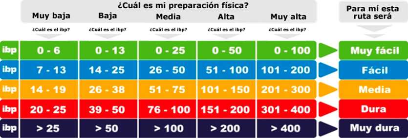
En cuanto a la dificultad es difícil en algún tramo , hay que bajarse de la bici e ir con cuidado para no caer sobre vallado con alambre de espino.
___________________
ENGLISH VERSION
The Aguardianteros
We leave from Alameda del Parral, crossing the urban area on Calle Hierro, passing through “Los Tejares” farm between olive trees and holm oaks and heading towards “Los Zarzares” through the “Las Mesas” stream, an area of special interest for what winding route and the great variety of fauna and flora.
Later we arrive at the road called "La Senda" and following the boundary between Alanís and Cazalla de la Sierra we pass the old "La Esperanza" halt and cross the Seville-Mérida railroad going up the "El Titulo" farm along a path, leaving a deep canyon on our right.
We continue to the junction with the Alanís-Cazalla highway and continue towards the water mills on the bank of Benalija, passing through the avenue and source of “Panfalto”, we will arrive at the old Alanís-Guadalcanal highway where we will turn right until we reach new to the town of Alanís.
As for the difficulty, it is difficult in some sections, you have to get off the bike and be careful not to fall on a fence with barbed wire.

You can add a comment or review this trail


Comments