
ECO-CICLE RUTA 29: R8 - Alanís. Parque Natural Sierra Norte de Sevilla
Trail photos


Author

Trail stats
- Distance
- 10.71 mi
- Elevation gain
- 427 ft
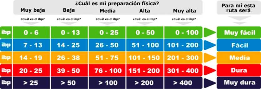
- Technical difficulty
- Easy
- Elevation loss
- 427 ft
- Max elevation
- 2,328 ft
- TrailRank
- 28
- Min elevation
- 1,944 ft
- Trail type
- Loop
- Time
- one day 8 minutes
- Coordinates
- 593
- Uploaded
- August 22, 2020
- Recorded
- February 2017
near Alanís, Andalucía (España)
Viewed 62 times, downloaded 5 times
Trail photos
Itinerary description
Esta ruta pertenece a la oferta BTT de Alanís:
Los Coscojales
Comenzamos desde la Alameda del Parral con un corto tramo urbano y de carretera hasta entrar en una pista forestal, circulando entre olivares para luego pasar a caminos entre encinas y monte bajo.
La vuelta la haremos hacia el casco urbano por veredas que circulan entre coscojas, encina y quejigos.
___________________
ENGLISH VERSION
Los Coscojales
We start from Alameda del Parral with a short urban and road section until we enter a forest track, circulating between olive groves and then passing to paths between holm oaks and scrubland.
We will make the return towards the urban area through paths that circulate between kermes oak, oak and gall oaks.
Los Coscojales
Comenzamos desde la Alameda del Parral con un corto tramo urbano y de carretera hasta entrar en una pista forestal, circulando entre olivares para luego pasar a caminos entre encinas y monte bajo.
La vuelta la haremos hacia el casco urbano por veredas que circulan entre coscojas, encina y quejigos.
___________________
ENGLISH VERSION
Los Coscojales
We start from Alameda del Parral with a short urban and road section until we enter a forest track, circulating between olive groves and then passing to paths between holm oaks and scrubland.
We will make the return towards the urban area through paths that circulate between kermes oak, oak and gall oaks.

You can add a comment or review this trail
Comments